


شرح مفصل عن نظام تحديد المواقع؟ What is GPS?
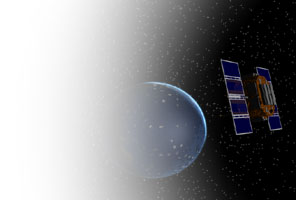
The Global Positioning System (GPS) is a satellite-based navigation system made up of a network of 24 satellites placed into orbit by the US Department of Defense. نظام تحديد المواقع العالمي (جي بي اس) هي أساس نظام الملاحة بالاقمار الصناعيه تتكون من شبكة من 24 قمرا صناعيا في المدار وضعت من قبل وزارة الدفاع الامريكية. GPS was originally intended for military applications, but in the 1980s, the government made the system available for civilian use. يهدف نظام تحديد المواقع أصلا للتطبيقات العسكرية ، ولكن في 1980s ، الحكومة هذا النظام متوفرا للاستخدام المدني. GPS works in any weather conditions, anywhere in the world, 24 hours a day. نظام تحديد المواقع يعمل في أي الأحوال الجوية ، في أي مكان في العالم ، 24 ساعة في اليوم. There are no subscription fees or setup charges to use GPS. لا توجد رسوم اشتراك أو رسوم الإعداد لاستخدام نظام تحديد المواقع.
How it works كيف يعمل
GPS satellites circle the earth twice a day in a very precise orbit and transmit signal information to earth. نظام تحديد المواقع الاقمار دائرة الأرض مرتين في اليوم في مدار دقيق جدا ونقل المعلومات إشارة إلى الأرض. GPS receivers take this information and use triangulation to calculate the user's exact location. أجهزة الاستقبال أغتنم هذه واستخدام المعلومات لحساب المثلثات مكان المستخدم بالضبط. Essentially, the GPS receiver compares the time a signal was transmitted by a satellite with the time it was received. The time difference tells the GPS receiver how far away the satellite is. أساسا ، وجهاز استقبال يقارن وقت أحيل إشارة من الأقمار الصناعية مع الوقت الذي وردت ، والفرق الوقت يحكي كيفية استقبال بعيدا الساتل. Now, with distance measurements from a few more satellites, the receiver can determine the user's position and display it on the unit's electronic map. الآن ، مع قياسات المسافة من الاقمار بضعة ، والاستقبال يمكن للمستخدم تحديد موقف وعرضه على وحدة الإلكترونية الخريطة.
A GPS receiver must be locked on to the signal of at least three satellites to calculate a 2D position (latitude and longitude) and track movement. يجب أن يكون هناك تأمين جهاز استقبال إشارة إلى ما لا يقل عن ثلاثة اقمار صناعية لحساب موقف 2D (خطوط الطول والعرض) ، وحركة المسار. With four or more satellites in view, the receiver can determine the user's 3D position (latitude, longitude and altitude). مع أربعة أو أكثر من الأقمار الصناعية في طريقة العرض ، يمكن للجهاز استقبال تحديد المستخدم 3D موقف (خطوط الطول والعرض والارتفاع). Once the user's position has been determined, the GPS unit can calculate other information, such as speed, bearing, track, trip distance, distance to destination, sunrise and sunset time and more. مرة واحدة وقد تم تحديد موقف للمستخدم ، يمكن تحديد المواقع وحدة حساب غيرها من المعلومات ، مثل السرعة ، واضعة ، المسار ، ومسافة الرحلة ، المسافة إلى شروق الشمس ، والمقصد والوقت غروب الشمس وأكثر من ذلك.
How accurate is GPS? ما مدى دقة تحديد المواقع؟
Today's GPS receivers are extremely accurate, thanks to their parallel multi-channel design. اليوم العالمي لتحديد المواقع الاستقبال ودقيقة للغاية ، وذلك بفضل تصميم موازية متعددة القنوات الخاصة بهم. Garmin's 12 parallel channel receivers are quick to lock onto satellites when first turned on and they maintain strong locks, even in dense foliage or urban settings with tall buildings. غارمين لاستقبال 12 قناة موازية يسارعون الى تلتحم الاقمار عند أول تشغيل ويحتفظون أقفال قوية ، حتى في أوراق الشجر الكثيفة أو المناطق الحضرية مع البنايات الشاهقة. Certain atmospheric factors and other sources of error can affect the accuracy of GPS receivers. والعوامل الجوية الأخرى من مصادر الخطأ يمكن معينة تؤثر على دقة أجهزة الاستقبال. Garmin® GPS receivers are accurate to within 15 meters on average. غارمين ® أجهزة الاستقبال دقيقة في حدود 15 مترا في المتوسط.
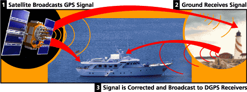
Newer Garmin GPS receivers with WAAS (Wide Area Augmentation System) capability can improve accuracy to less than three meters on average. غارمين أحدث أجهزة الاستقبال مع واس (منطقة واسعة نظام التعزيز) ويمكن تحسين القدرة على دقة إلى أقل من ثلاثة أمتار في المتوسط. No additional equipment or fees are required to take advantage of WAAS. معدات أو رسوم إضافية لا يلزم للاستفادة من واس. Users can also get better accuracy with Differential GPS (DGPS), which corrects GPS signals to within an average of three to five meters. ويمكن للمستخدمين أيضا الحصول على أفضل دقة مع نظام تحديد المواقع التفاضلي (النظام التفاضلي) ، الذي بتصحيح إشارات نظام تحديد المواقع في غضون فترة متوسطها 3-5 متر. The US Coast Guard operates the most common DGPS correction service. This system consists of a network of towers that receive GPS signals and transmit a corrected signal by beacon transmitters. قوات حرس السواحل الامريكية تعمل على تصحيح النظام التفاضلي الأكثر شيوعا خدمة هذا النظام يتكون من شبكة من الأبراج التي تتلقى إشارات نظام تحديد المواقع ، ويحيل إشارة تصحيحها عن طريق الإرسال منارة. In order to get the corrected signal, users must have a differential beacon receiver and beacon antenna in addition to their GPS. من أجل الحصول على إشارة تصحيح ، يجب أن المستخدمين لديهم جهاز استقبال وهوائي التفاضلية منارة منارة بالإضافة إلى نظام تحديد المواقع الخاصة بهم.
The GPS satellite system نظام تحديد المواقع الفضائية
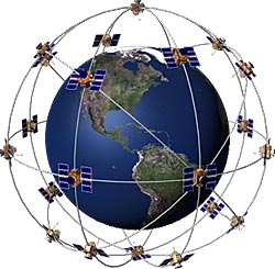
The 24 satellites that make up the GPS space segment are orbiting the earth about 12,000 miles above us. الأقمار الصناعية 24 التي تشكل الجزء الفضائي لتحديد المواقع هي التي تدور حول الأرض حوالي 12000 كيلومتر فوقنا. They are constantly moving, making two complete orbits in less than 24 hours. انهم يتحركون باستمرار ، مما يجعل اثنين مدارات كاملة في أقل من 24 ساعة. These satellites are travelling at speeds of roughly 7,000 miles an hour. هذه الأقمار يسافرون بسرعة نحو 7000 كيلومتر في الساعة.
GPS satellites are powered by solar energy. تعمل بالطاقة عن طريق الأقمار الصناعية لتحديد المواقع الطاقة الشمسية. They have backup batteries onboard to keep them running in the event of a solar eclipse, when there's no solar power. لديهم على متن البطاريات الاحتياطية لابقائهم قيد التشغيل في حالة حدوث كسوف الشمس ، عندما لم يكن هناك الطاقة الشمسية. Small rocket boosters on each satellite keep them flying in the correct path. معززات صاروخية صغيرة على كل الأقمار الصناعية الاحتفاظ بها تحلق في المسار الصحيح.
Here are some other interesting facts about the GPS satellites (also called NAVSTAR, the official US Department of Defense name for GPS): وفيما يلي بعض حقائق مثيرة للاهتمام أخرى حول الأقمار الصناعية (وتسمى أيضا نافستار ، مسؤول وزارة الخارجية الأميركية اسم وزير الدفاع لتحديد المواقع) :
- The first GPS satellite was launched in 1978. وتم إطلاق القمر لتحديد المواقع الأولى في عام 1978.
- A full constellation of 24 satellites was achieved in 1994. وتم التوصل إلى كوكبة كاملة من 24 قمرا صناعيا في عام 1994.
- Each satellite is built to last about 10 years. بنيت كل الأقمار الصناعية إلى الماضي عن 10 عاما. Replacements are constantly being built and launched into orbit. باستمرار الاستبدال يجري بناؤها وانطلق في المدار.
- A GPS satellite weighs approximately 2,000 pounds and is about 17 feet across with the solar panels extended. قمر صناعي لتحديد المواقع يزن حوالي £ 2000 وحوالي 17 قدما عبر الألواح الشمسية مع الموسعة.
- Transmitter power is only 50 watts or less. الارسال السلطة فقط 50 واط أو أقل.
What's the signal? ما هو إشارة؟
GPS satellites transmit two low power radio signals, designated L1 and L2. الأقمار الصناعية لتحديد المواقع أحيل اثنان راديو الطاقة المنخفضة الإشارات ، المعين L1 و L2. Civilian GPS uses the L1 frequency of 1575.42 MHz in the UHF band. المدنية لتحديد المواقع يستخدم التردد L1 من 1575.42 ميغاهيرتز في نطاق التردد فوق العالي. The signals travel by line of sight, meaning they will pass through clouds, glass and plastic but will not go through most solid objects such as buildings and mountains. الإشارات سفر خط الأفق ، وهذا يعني أنها سوف تمر من خلال الغيوم ، والزجاج والبلاستيك ولكن لن يمر معظم الأجسام الصلبة مثل المباني والجبال.
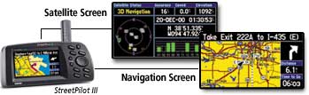
A GPS signal contains three different bits of information - a pseudorandom code, ephemeris data and almanac data. إشارة لتحديد المواقع يحتوي على ثلاثة أجزاء مختلفة من المعلومات -- وهو رمز المزيف ، وبيانات التقويم الفلكي وبيانات التقويم. The pseudorandom code is simply an ID code that identifies which satellite is transmitting information. رمز المزيف هو مجرد رمز الهوية التي تحدد القمر الصناعي الذي نقل المعلومات. You can view this number on your Garmin GPS unit's satellite page, as it identifies which satellites it's receiving. يمكنك مشاهدة هذا الرقم على وحدة الأقمار الصناعية لتحديد المواقع صفحة غارمين الخاص ، كما تحدد الاقمار الصناعية التي انها المستقبلة.
Ephemeris data, which is constantly transmitted by each satellite, contains important information about the status of the satellite (healthy or unhealthy), current date and time. بيانات التقويم الفلكي ، والتي تبث باستمرار من قبل كل الأقمار الصناعية ، ويحتوي على معلومات هامة حول وضع القمر الصناعي (صحي أو غير صحي) ، التاريخ والوقت الحالي. This part of the signal is essential for determining a position. هذا الجزء من الإشارة ضرورية لتحديد موقف.
The almanac data tells the GPS receiver where each GPS satellite should be at any time throughout the day. البيانات تقويم يحكي جهاز استقبال الأقمار الصناعية لتحديد المواقع حيث كل ينبغي أن تكون في أي وقت طوال اليوم. Each satellite transmits almanac data showing the orbital information for that satellite and for every other satellite in the system. كل قمر صناعي ينقل البيانات تقويم عرض المعلومات المدارية لهذا القمر الصناعي ولكل قمر صناعي آخر في النظام.
Sources of GPS signal errors مصادر الأخطاء إشارة لتحديد المواقع
Factors that can degrade the GPS signal and thus affect accuracy include the following: العوامل التي يمكن أن تتحلل في إشارة لتحديد المواقع وبالتالي تؤثر على دقة ما يلي :
- Ionosphere and troposphere delays - The satellite signal slows as it passes through the atmosphere. الأيونوسفير وطبقة التروبوسفير التأخير -- إشارة القمر الصناعي يتباطأ لأنها تمر عبر الغلاف الجوي. The GPS system uses a built-in model that calculates an average amount of delay to partially correct for this type of error. ويستخدم نظام تحديد المواقع المدمج في النموذج الذي يحسب مبلغ متوسط التأخير لتصحيح جزئيا لهذا النوع من الخطأ.
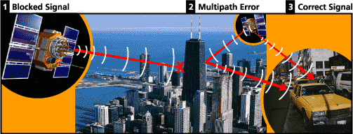
- Signal multipath - This occurs when the GPS signal is reflected off objects such as tall buildings or large rock surfaces before it reaches the receiver. إشارة المتعددة -- وهذا يحدث عندما تكون إشارة لتحديد المواقع وينعكس قبالة كائنات مثل أسطح البنايات الشاهقة أو صخرة كبيرة قبل أن تصل إلى المتلقي. This increases the travel time of the signal, thereby causing errors. وهذا يزيد من الوقت الذي يستغرقه السفر للإشارة ، مما يسبب أخطاء.
- Receiver clock errors - A receiver's built-in clock is not as accurate as the atomic clocks onboard the GPS satellites. Therefore, it may have very slight timing errors. أخطاء استقبال على مدار الساعة -- المتلقي الذي بني في الساعة ليست كذلك دقة الساعات الذرية على متن الطائرة لتحديد المواقع. الأقمار الصناعية وبالتالي ، فإنه قد يكون توقيت اخطاء طفيفة جدا.
- Orbital errors - Also known as ephemeris errors, these are inaccuracies of the satellite's reported location. أخطاء المداري -- ويعرف أيضا أخطاء التقويم الفلكي ، وهذه هي معلومات غير دقيقة من الأقمار الصناعية التي نقلت عن الموقع.
- Number of satellites visible - The more satellites a GPS receiver can "see," the better the accuracy. عدد الأقمار الصناعية مرئية -- وأكثر جهاز استقبال الأقمار الصناعية يمكن ان "انظر" ، وأفضل دقة. Buildings, terrain, electronic interference, or sometimes even dense foliage can block signal reception, causing position errors or possibly no position reading at all. المباني والتضاريس ، والتدخل الإلكترونية ، أو في بعض الأحيان يمكن أن أوراق الشجر الكثيفة حتى منع استقبال الإشارات ، مما تسبب في أخطاء الموقف أو ربما لا قراءة الموقف على الإطلاق. GPS units typically will not work indoors, underwater or underground. وحدات لتحديد المواقع وعادة لا تعمل في الداخل ، تحت الماء أو تحت الأرض.
- Satellite geometry/shading - This refers to the relative position of the satellites at any given time. الهندسة الفضائية / تظليل -- وهذا يشير إلى الموضع النسبي للسواتل في أي وقت معين. Ideal satellite geometry exists when the satellites are located at wide angles relative to each other. مثالية الهندسي للأقمار الصناعية موجود عندما تقع في زوايا الاقمار واسعة بالنسبة لبعضها البعض. Poor geometry results when the satellites are located in a line or in a tight grouping. سوء النتائج هندسة عندما تقع الاقمار في خط التجميع أو في ضيق.
- Intentional degradation of the satellite signal - Selective Availability (SA) is an intentional degradation of the signal once imposed by the US Department of Defense. تدهور متعمد للاشارات القمر الصناعى -- الإتاحة الانتقائية) هو تدهور المتعمد للإشارة فرضها مرة من قبل وزارة الدفاع الامريكية. SA was intended to prevent military adversaries from using the highly accurate GPS signals. سا المقصود هو منع الاعداء العسكرية من استخدام إشارات دقيقة للغاية لتحديد المواقع. The government turned off SA in May 2000, which significantly improved the accuracy of civilian GPS receivers. الحكومة تحولت قبالة سا مايو 2000 ، مما أدى إلى تحسن ملحوظ في دقة أجهزة الاستقبال المدنيين.
- مترجم من جوجل

الاشتراك في:
تعليقات الرسالة (Atom)


21 نوفمبر 2010 في 5:44 م
هى دى المعلومات المفيدة عن جد
شـــــــــكــــــــــراً
4 فبراير 2014 في 8:33 م
يحتوي هذا الموقع على معلومات ومواضيع منوعة و مفيدة جدا أتمنى أن أطلع على جزء كبير منها